


The Montour Trail: the Nation’s Longest Suburban Rail-Trail!
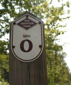 The scenic Montour Trail’s main line travels from Coraopolis to Clairton. Branch trails extend into Bethel Park, Westland, and the Pittsburgh International Airport. The Trail is continuous from MM 0.0 near Coraopolis to Library, around MM 36. The mostly volunteer Montour Trail Council (MTC) is working to close several short gaps in the the south.
MTC privately owns, develops, manages, and maintains the trail. As a 501 (c)(3) non-for-profit organization, MTC receives no recurring tax-based support. The organization does receive funding from the PA Department of Conservation and Natural Resources and other agencies for trail building and major capital projects.
Trail Surface
The rail-trail pavement is a relatively smooth surface of crushed limestone, which makes it ideal for all forms of non-motorized use. There are a few sections that are asphalt, which makes it easier to navigate hazards like inclines, blind curves and road crossings. People enjoy the Montour Trail for bicycling, walking, running, cross-country skiing, dog-walking and nature appreciation. Hunters and fishermen also appreciate the access the Trail provides to prime spots. In certain sections, horseback riding is permitted, but not on the improved Trail surface.
Trailhead Access
You can access the Trail via 25+ trailheads, conveniently located every few miles. These gateways offer parking (including handicapped), water fountains (in season), benches, picnic shelters and portable toilets (mostly in season). In addition, the Trail hosts a number of campsites for through-travelers bicycling to the GAP (Great Allegheny Passage) and C&O Canal routes to Washington, DC.
A portion of the Trail within Peters Township is the Arrowhead Trail, owned and maintained by that township. When it was built in 1985, the township planted 500 trees along the 4-mile route, providing a wooded corridor that links Peters’ neighborhoods with parks.
Branches & Connectors

The Westland branch runs parallel to an active rail line.
Several branches provide access beyond the main line:
- The Westland Branch extends from Venice to Westland, a 4.1-mile stretch that offers rural beauty and solitude. It runs parallel to an active railroad line.
- The Bethel Park Branch runs 2.8 miles through forested and residential neighborhoods. Volunteers there are purchasing property and acquiring rights-of-way to extend the mileage.
- The Airport Connector is a combination trail/on-road link that runs about 6 relatively flat miles from ~MP 8 to the airport parking lot. This feature makes Pittsburgh more accessible to bicycle tourists.
Several short Trail connectors are under construction:
- The Coraopolis Connector will link MM 0 with the town of Coraopolis.
- The Muse Connector will lead to McConnell Trails east of Cecil, ~MM 25.
- The Southpointe Connector will branch off the Montour Trail near MM 26 toward the growing business park near Canonsburg. Bicycling commuters are especially interested in this route.
Linking Trails
A network of trails — suburban/rural, sunny/shaded, quiet/bustling, but never steep — crisscrosses hilly Pittsburgh, with the Montour Trail as its anchor. The Montour Trail connects in McDonald (MP 17.3) to the Panhandle Trail, which stretches 29 miles between Carnegie, Pennsylvania, and Weirton, West Virginia. Its original train corridor once connected Pittsburgh to Cincinnati, Chicago, and St. Louis.
At the Montour’s southeastern terminus in Clairton, you can take the Clairton Connector route (urban, on-road) about 5 miles to McKeesport, which links to the GAP (Great Allegheny Passage). Turn north at this junction and you can travel about 15 miles to downtown Pittsburgh along the Monongahela River. Or turn south to follow the Youghiogheny River to the Allegheny Mountains and beyond.
The Montour Trail connects Pittsburgh International Airport to the GAP and the C&O Canal Towpath. This trail system stretches 300+ miles from Pittsburgh to Washington, DC. Inside the airport, baggage claim hosts an area where bicyclists can disassemble/reassemble their bikes pre-/post-flight.
Survey Says … What Our Users Think
More than 400,000 people use the Montour Trail each year. Every few years, MTC conducts a survey to learn what they think of this great resource. We leverage the results to make Trail improvements that help draw in new people from all over.
Survey results do make a difference. Based on user comments in 2016, we added more year-round portable toilets, directional/distance signage along the Trail, and water fountains.
That survey also listed questions about etiquette. The responses reinforced the idea that we can all make improvements in this area, from bicyclists’ passing/speeding to pet-leash enforcement to walking/running two-to-three abreast. We developed safety and etiquette guidelines that encourage respectful behavior.
The 2021 survey revealed that top user concerns include clear trailhead signage, year-round toilet facilities, and adequate parking access — topics that will be prioritized as MTC updates its strategic plan. You can review the latest survey results here.
Railroad Connections
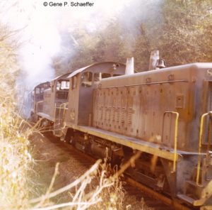 The converted railway bed has a significant industrial history. It began life as the coal-carrying Montour Railroad (MRR) in the late 1800s. In its heyday, MRR trains served 27 mines and carried 7 million tons of coal per year. People once called Pittsburgh the “dirty city,” because the coal-fired steel mills left a dusting of black grit everywhere. Even so, the product that built our industrialized nation saw us through two world wars.
Dotted with refurbished railroad truss bridges, replacement spans that are engineering marvels, and lengthy tunnels that eliminate steep grades, the Trail offers views of beautiful rural landscapes, wooded corridors, open-sky green spaces, and babbling creeks. Still, the suburban towns along the route provide many opportunities for refreshment and diversion.